


1 ma trace nd garde-ruine Spaeny

ego
User
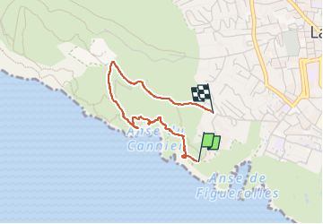

Length
2.7 km

Max alt
140 m

Uphill gradient
106 m
Km-Effort
4.2 km

Min alt
32 m

Downhill gradient
128 m
Boucle
No
Creation date :
2025-01-07 11:50:40.654
Updated on :
2025-01-24 13:37:52.68
1h05
Difficulty : Easy

FREE GPS app for hiking
 SityTrail
IGN / Geographical institutes
SityTrail Plus
The world is yours!
About
Trail Walking of 2.7 km to be discovered at Provence-Alpes-Côte d'Azur, Bouches-du-Rhône, La Ciotat. This trail is proposed by ego .
Description
1 er partie 7 janvier
Photos


Positioning
Country:
France
Region :
Provence-Alpes-Côte d'Azur
Department/Province :
Bouches-du-Rhône
Municipality :
La Ciotat
Location:
Unknown
Start:(Dec)
Start:(UTM)
710733 ; 4782597 (31T) N.
Comments